
Regardless of the type of analysis planned, it is necessary to first acquire the data required for them. To this end, we meticulously plan and then execute a flight, during which we acquire image material. Depending on the target product and its purpose, the drone can be equipped with a high-resolution RGB, multispectral or thermal camera.


Dedicated equipment:
X-01 multi-rotor Hexacopter, X-05 aircraft, Phantom 4, Inspire 2.

Service parameters:
- execution time depends on the legally defined availability of airspace, the area to be mapped and weather conditions (minimum 1 day),
- Time from placing the order to conducting the raid: 3-4 days (may may be extended if the area to be raided exceeds 200ha)
- unprocessed images transmitted after the raids.

Service Description:
- Planning and execution of a photogrammetric raid over the designated area,
- Transfer of unprocessed footage.

What you get:
Unprocessed RGB or multispectral footage.
The number of drones in the hands of farmers is increasing every year, which, at least in theory, allows them to obtain the photogrammetric products they need on their own. The part of the process that requires more knowledge than that needed for automated flight is data processing and analysis. If you can collect the necessary data, but don't have a powerful workstation with photogrammetric or GIS software at your disposal, CUD is happy to relieve you of the burden in this area. We will generate a suitable product for you and deliver it in the required format.

Dedicated Software:
Agisoft Metashape, Pix4D, QGIS.
Service parameters:
- Time from order to receipt of product and report: 3-4 days (may be extended if the area analyzed is more than 200 hectares),
- A report with maps and the results of the analysis provided in electronic (.pdf, .shp, .gpkg) or paper form.
Service Description:
- acquisition of non-processed data from the customer,
- generation of a selected photogrammetric product, viz: orthophoto, 3D model, point cloud or index map,
- Possible analysis of the results obtained (e.g., measuring the surface, creating an application map or conducting hydrological simulations)
What you get:
The selected photogrammetric product with the results of any analysis in the form of a report.
Remote sensing in agriculture is not just about fertilization maps. Using information collected by drones and artificial intelligence, we are able to count the seedlings in your field and determine the number of losses. This allows us to optimize production volumes and reduce opportunity costs.

Dedicated equipment:
Multirotor Hexacopter X-01, Aircraft X-05, Phantom 4, Agrodron X-06, Inspire 2.
Service parameters:
- execution time depends on the legally defined availability of airspace, the area to be mapped and weather conditions (minimum 1 day),
- time from placing an order to conducting a raid: 3-4 days (may be extended if the area to be raided exceeds 200ha),
- A report with maps and analysis results submitted in electronic (.pdf, .shp, .gpkg) or paper form.
Service Description:
- Performing a photogrammetric raid over the designated area,
- generation of orthophotos,
- possible development of orthophoto transformation (highlighting plants against the soil),
- evaluation of uniformity of sowing (whether there are losses, how many, where) - automating seedling counts.
What you get:
Sowing uniformity map + analysis report.
Accurate information about the condition of crops allows us to address threats more accurately and quickly. Using drones and advanced technology, we provide reliable information about the health of a crop at every stage of its development.

Dedicated equipment:
X-01 multi-rotor Hexacopter, X-05 aircraft, Agrodron X-06, Inspire 2.
Service parameters:
- execution time depends on the legally defined availability of airspace, the area to be mapped and weather conditions (minimum 1 day),
- time from placing the order to receiving the report: 3-4 days (may extend if the area is more than 200 hectares),
- A report with maps and analysis results submitted in electronic (.pdf, .shp, .gpkg) or paper form.
Service Description:
- Performing a raid with a drone equipped with a multispectral camera,
- Generation of indicator maps,
- Analysis of the indicator map and identification of problem areas.
What you get:
Indicator map (or/and RGB orthophotomap) + condition report Crops with indication of problem areas.
Variable fertilization based on vegetation data has already entered farming practice permanently. Drones allow us to go one step further by fitting into the Green Deal strategy. Thanks to high-resolution images, we can already see not only the overall condition of the crop but even individual weeds. Spot spraying in an orchard or vineyard? Precision spraying with drones? That's what we do at CUDa!

Dedicated equipment:
X-01 multi-rotor Hexacopter, X-05 aircraft, Agrodron X-06, Inspire 2.
Service parameters:
- execution time depends on the legally defined availability of airspace, the area to be mapped and weather conditions (minimum 1 day),
- time from placing the order to receiving the report: 3-4 days (may extend if the area is more than 200 hectares),
- The application map is provided in electronic (.shp format) and overview (pdf) form.
Service Description:
- Performing a raid with a drone equipped with a multispectral camera,
- Generation of indicator maps,
- Analysis of the indicator map and its conversion to an application map
What you get:
Application map in electronic (ormat .shp) and overview (pdf) form.
Worse crop condition is not always necessarily related to agrophage activity. If the problems are related to irrigation, multispectral analysis may not be enough. However, we have solutions for such eventualities as well! With the right set of sensors and analytical algorithms, we are able to detect problems with both excess and shortage of water.

Dedicated equipment:
X-01 multi-rotor hexacopter, X-05 airplane, Agrodron X-06, Inspire 2.
Service parameters:
- execution time depends on the legally defined availability of airspace, the area to be mapped and weather conditions (minimum 1 day),
- Time from placing the order to receiving the report: usually about 3-4 days (the period may be extended if the area analyzed area is more than 200 hectares),
- A report with maps and the results of the analysis provided in the form of Electronic (.pdf) or hard copy.
Service Description:
- Performing a raid with a drone equipped with a multispectral camera,
- Generation of RGB orthophotos, index maps and NMT,
- analysis of photogrammetric products,
- Identifying the stressor(s) and determining the level of stress.
What you get:
Mapping studies with final report.
Desiccation is another treatment where drones allow us to support field operations. Through the use of BSL, we are able to determine which area should be sprayed and where it is no longer necessary. This reduces the cost of the treatment and its impact on the environment.

Dedicated equipment:
X-01 multi-rotor Hexacopter, X-05 aircraft, Agrodron X-06, Inspire 2.
Service parameters:
- execution time depends on the legally defined availability of airspace, the area to be mapped and weather conditions (minimum 1 day),
- time from placing the order to receiving the report: usually about 3-4 days (time may increase if the area of the analyzed area is more than 200 hectares),
- A report with maps and the results of analysis provided in the form of electronic (pdf) or paper.
Service Description:
- Performing a raid with a drone equipped with a multispectral camera,
- Generation of indicator maps,
- Transforming reflektance maps into indicator maps,
- Analysis of the indicator map and its conversion to a zonal spray map,
What you get:
RGB orthophotomap, spray map in overview format (.pdf) and electronic - ready for import in the machine (.shp).
Precision farming technologies are not just made for large-scale crops. In the area of precision horticulture, drones allow us not only to map crops, but also to estimate the production potential of individual fruit trees or bushes. Thanks to such analyses, we are able to track the productivity of individual varieties, the load on the bushes, the effects of applied fertilization or other agrotechnical treatments. Precision horticulture with drones is also a chance to use application maps of variable fertilization and spraying for classic tools but also zonal aerial spraying.

Dedicated equipment:
Airplane X-05, Agrodron X-06, Multi-rotor Hexacopter X-01, Phantom 4.
Service parameters:
- execution time depends on the legally defined availability of airspace, the area to be mapped and weather conditions (minimum 1 day),
- time from placing the order to receiving the report: 5 days (the time may be extended if the area analyzed is more than 200 hectares),
- A report with maps and the results of the analysis provided in the form of electronic (pdf) or paper.
Service Description:
- Performing a photogrammetric raid with a drone equipped with a camera multispectral camera over the indicated area,
- Generation of RGB orthomosaics and indicator maps,
- calculation of the number of trees,
- Transformation of indicator maps into application maps,
What you get:
Orthophotomap + report determining the number of trees, application map.
Drones are an ideal tool for producing reliable documentation of crop damage. Using high-resolution images, we can create accurate maps of the field, avoiding the errors associated with traditional measurement methods. Accurate measurement of damage can significantly speed up the process of obtaining financial assistance or compensation, as well as help plan measures to protect crops and young tree plantings.

Dedicated equipment:
Airplane X-05, Agrodron X-06, Multi-rotor Hexacopter X-01, Phantom 4.
Service parameters:
- Implementation time depends on the possibilities arising from airspace regulations, acreage of the mapped area and weather conditions (minimum 1 day),
- time from order to receipt of report: 5 days (may be extended if the area is more than 200 hectares),
- A report with maps and the results of the analysis provided in the form of Electronic (.pdf) or hard copy.
Service Description:
- execution of a photogrammetric raid over the indicated area,
- Generation of RGB orthophotos, index maps and NMT,
- Performing damage classification in the study area,,
- Generate a damage map with an accurate measurement of the area covering each class.
What you get:
RGB orthophotomap, index map, final report with damage measurement and classification.
The European corn borer is a pest that every corn farmer has surely heard of. Without continuous monitoring of the crop and taking timely preventive steps, its yield loss can be up to 90%. The corn borer is a natural enemy of the corn borer. Its larvae parasitize its eggs, preventing the pest's population from increasing. Thanks to Agrodron, we are able to locate feeding foci of the European corn borer and spot-apply Kruszynek in loose form.

Dedicated equipment:
Agrodron X-06, Multi-rotor Hexacopter X-01.
Service parameters:
- Implementation time dependent on the possibilities under the regulations of airspace, acreage of the drop area and weather conditions (minimum 1 day).
Service Description:
- Flight plan preparation,
- Conducting airborne operations and airdropping the Crumbler.
What you get:
Treatment with a biological agent to control the European corn borer European corn borer.
Regardless of the type of analysis planned, it is necessary to first acquire the data required for them. To this end, we meticulously plan and then execute a flight, during which we acquire image material. Depending on the target product and its purpose, the drone can be equipped with a high-resolution RGB, multispectral or thermal camera.

Dedicated equipment:
X-01 multi-rotor Hexacopter, X-05 aircraft, Phantom 4, Inspire 2.
Service parameters:
- Implementation time depends on the possibilities arising from airspace regulations, acreage of the mapped area and weather conditions (minimum 1 day),
- time from requesting an order to conducting a raid: 3-4 days (may extend if the area is more than 200 hectares),
- unprocessed images transmitted after the raids.
Service Description:
- Planning and execution of a photogrammetric raid over the designated area,
- Transfer of unprocessed footage.
What you get:
Unprocessed RGB or multispectral footage.
Drones have already made their home in the National Forests, allowing foresters to streamline inventory work. However, the presence of BSL in the Forest District does not always mean at the same time having the infrastructure or software required to process and analyze photogrammetric data. Dear Foresters - if you are facing just such limitations, you are cordially invited to CUD. We will generate the necessary product for you and deliver it in the required format.

Dedicated equipment:
Agisoft Metashape, Pix4D, Qgis.
Service parameters:
- Time from order to receipt of product and report: 3-4 days (may extend if the area is more than 200 hectares),
- Photogrammetric studies (orthophotomosaics, point clouds, 3d models or indicator maps), report with maps and analysis results provided In electronic (.pdf) or paper form.
Service Description:
- Obtaining raw data from the customer,
- Development of a selected photogrammetric product or remote sensing, including orthophotos, 3D model, point cloud or index map with a specific index calculated,
- Possible analysis of the results obtained (e.g., measuring the area, assessing stand health, locating mistletoe or conducting hydrological simulations).
What you get:
Selected photogrammetric product with possible analysis In the form of a report.
Sensors mounted on the BSL allow the generation of data helpful in very many aspects of forest monitoring. From "classic" RGB maps, through multispectral maps useful for classification and assessment of tree condition, to numerical models allowing to determine stand growth. At the Drone Service Center, we have the right tools to provide Foresters with the data they need to accurately inventory the resources they oversee.

Dedicated equipment:
Aircraft X-05, Agrodron X-06, Multi-rotor Hexacopter. X-01.
Service parameters:
- Implementation time depends on the possibilities arising from airspace regulations, acreage of the mapped area and weather conditions (minimum 1 day),
- time from notification of the order to conduct the raid: 5 days (the period may be extended if the area is more than 200 hectares),
- A report with maps and the results of the analysis provided in the form of Electronic (.pdf) or hard copy.
Service Description:
- execution of a photogrammetric raid over the indicated area,
- generation of photogrammetric products,
- Conducting stand analyses (e.g., calculating crown area, or determining leaf cover index (LAI),
What you get:
Mapping studies with a report summarizing the analyses.
A drone equipped with a multispectral camera allows the assessment of the condition of of the stand, which in this case can manifest itself in the degree of defoliation i.e. loss of leaves or needles due to external factors, such such as air pollution or plant diseases. Leaf loss expressed percentage is a criterion for assessing forest health by bioindication.

Dedicated equipment:
Aircraft X-05, Agrodron X-06, Multi-rotor Hexacopter. X-01.
Service parameters:
- Implementation time dependent on the possibilities arising from airspace regulations, acreage of mapped area and weather conditions (minimum 1 day),
- time from order to receipt of report: 5 days (may extend if the area is more than 200 hectares),
- A report with maps and the results of the analysis provided in electronic (pdf) or paper form.
Service Description:
- execution of a photogrammetric raid over the indicated area,
- orthophoto generation,
- Crown segmentation and vegetation analysis,
What you get:
Mapping studies with defoliation level report.
Indicator maps, obtained on the basis of data collected during raids with our BSL, allow us to accurately determine the condition of trees. By analyzing them, we are able to classify the stand, indicating healthy as well as problematic areas of the forest. Importantly, thanks to the use of multispectral cameras, we are able to indicate with high precision not only trees already significantly damaged, but also those at a very early stage of infection. This contributes to making faster and more optimal decisions on forest management, thereby reducing the scale of intervention cuts in forests.

Dedicated equipment:
Aircraft X-05, Agrodron X-06, Multi-rotor Hexacopter. X-01.
Service parameters:
- Implementation time depends on the possibilities arising from airspace regulations, acreage of the mapped area and weather conditions (minimum 1 day),
- time from order to receipt of report: 3-4 days (may extend if the area of the forest department is more than 200 ha),
- A report with maps and the results of analysis provided in the form of electronic (pdf) or paper.
Service Description:
- The execution of a flightudron equipped with a multispectral camera,
- Generation of indicator maps,
- stand classification and development of results
What you get:
Mapping studies and a report determining the condition of the stand.
Drones equipped with multispectral cameras effectively locate trees infested by the bark beetle. The data acquired from the air makes it possible to protect healthy trees and take pinpoint action against infected ones.

Dedicated equipment:
Aircraft X-05, Agrodron X-06, Multi-rotor Hexacopter. X-01.
Service parameters:
- Implementation time depends on the possibilities arising from airspace regulations, acreage of the mapped area and weather conditions (minimum 1 day),
- time from order notification to receipt of the report: 5 days (may be extended if the surveyed area is more than 200 hectares),
- A report with maps and the results of the analysis provided in the form of Electronic (.pdf) or hard copy.
Service Description:
- Execution of a BSL raid equipped with a multispectral camera,
- generation of orthomosaics (RGB and multispectral)/li>.
- Generation and analysis of indicator maps,
- Classification of stands and assessment of their condition.
What you get:
Mapping studies with a report summarizing the results of the analyses.
Mistletoe is a characteristic semi-parasite that attaches itself to the host tree and takes water and mineral salts from it. Single mistletoes do not threaten the tree, but when there are many of them, they make it die.In recent years, in addition to the common mistletoe, which attacks deciduous trees, the common spider mistletoe is increasingly common, colonizing mainly pine trees, making it a significant threat to coniferous forests. Monitoring the occurrence of mistletoe from the ground is extremely difficult. For this reason, regular mapping of trees using a drone is crucial. This allows us to make optimal decisions on the timing of felling (so that the raw timber does not lose its value).

Dedicated equipment:
Aircraft X-05, Agrodron X-06, Multi-rotor Hexacopter. X-01.
Service parameters:
- Implementation time depends on the possibilities arising from airspace regulations, acreage of the mapped area and weather conditions (minimum 1 day),
- time from order to receipt of report: 5 days (may extend if the surveyed area is larger than 200 hectares),
- Mapping studies together with a report describing the results of the analyses in the form of Electronic (.pdf) or hard copy.
Service Description:
- execution of a raid with a drone equipped with a camera multispectral,
- Generation of indicator maps,
- Transforming reflektance maps into indicator maps,
- Stand classification and settlement analysis,
- Generate a mistletoe settlement report.
What you get:
Mapping studies with a report on the analyses carried out.
Our BSLs are equipped not only with RGB and multispectral cameras but also thermal imaging cameras. They make it significantly easier to count wildlife in wooded areas and extend working hours into the night, when other sensors would no longer be helpful. CUD drones are also characterized by a long flight time, which makes it possible to map larger areas of land during a single flight, increasing the efficiency of the observations made.

Dedicated equipment:
X-01 Multi-rotor Hexacopter.
Service parameters:
- The implementation time depends on the possibilities arising from the regulations of the airspace. airspace regulations, acreage of the mapped area and weather conditions (minimum 1 day),
- time from order to receipt of report: 5 days (may extend if the surveyed area exceeds 200 hectares),
- inventory report submitted in the form of electronic (pdf) or paper.
Service Description:
- Drone raids with a thermal imaging camera and surveillance,
- Inventory based on recorded film/photographs taken.
What you get:
Inventory report and original records/photos.
Increasingly severe droughts pose a real threat to forest stands and management. Effective identification of fire-prone areas is the cornerstone of a fire information system. Equipped with thermal imaging cameras, CUD's drones are able to locate areas of smoldering litter as well as burnt areas that still pose a fire risk.

Dedicated equipment:
X-01 Multi-rotor Hexacopter.
Service parameters:
- Implementation time dependent on the possibilities under the regulations of airspace, acreage of the mapped area and weather conditions (minimum 1 day),
- time from order to receipt of report: 5 days (may be extended if the the surveyed area is more than 200 hectares),
- report with fire hazard maps submitted in the form of electronic (pdf) or paper.
Service Description:
- Planning the route of the raid,
- execution of a raid with a drone equipped with a camera thermal imaging,
- Development of a fire hazard report.
What you get:
Fire Danger Report.
Drones are an extremely effective medium for collecting the data needed for SIP operations. A single raid with our UAV is enough to obtain several types of spatial data: high-resolution orthophotos, point clouds necessary for surveying, or 3d models ideal for visualization. Never before has a SIP update been so fast and economical!

Dedicated equipment:
Airplane X-05, Agrodron X-06, Multi-rotor Hexacopter X-01, Phantom 4, Inspire 2.
Service parameters:
- Implementation time dependent on the possibilities under the regulations of airspace, acreage of the mapped area and weather conditions (minimum 1 day),
- Time from placing the order to receiving the report: usually about 3-4 days,
- ordered photogrammetric product available for electronic download.
Service Description:
- execution of a photogrammetric raid over the specified area,
- Generation of the ordered photogrammetric product, i.e. high-resolution orthophoto, 3D model, point cloud, numerical terrain models (NMT/NMPT/ZNMPT),
- transfer of processing products to the customer.
What you get:
Specified photogrammetric products: high-resolution orthophoto, 3D model, point cloud, numerical terrain models.
The use of drones in monitoring hard-to-reach areas is often the only way to survey the administered area effectively and safely for the surveyor. Periodic flights conducted in such areas allow to track changes in the environment, the scale and pace of phenomena occurring on them and, in the event of a natural disaster, to quickly determine the extent of damage that will need to be eliminated in the future.

Dedicated equipment:
X-01 multi-rotor Hexacopter, X-05 aircraft, Phantom 4, Inspire 2.
Service parameters:
- Implementation time dependent on the possibilities under the regulations of airspace, acreage of the mapped area and weather conditions (minimum 1 day),
- time from order submission to report receipt: 5 days (may extend- extend if the area exceeds 200 hectares),
- Report with maps and damage analysis provided in electronic (.pdf) or paper form.
Service Description:
- Performing a photogrammetric raid over the specified area ,
- generation of orthophotos,
- classification and measurement of damages.
What you get:
Mapping studies with a report summarizing the results of the analyses.
The star wasp (Acantholyda posticalis) is another - next to the bark beetle - pest of coniferous trees that has appeared in Polish forests. However, as in the case of the bollworm, biological counteraction can be used to combat it with the help of Kruszynek. The drop is carried out from the air using Agrodron over previously located outbreaks of Osnuia.

Dedicated equipment:
Agrodron X-06, Multi-rotor Hexacopter X-01.
Service parameters:
- Implementation time dependent on the possibilities under the regulations of airspace, acreage of the drop area and weather conditions (minimum 1 day)
Service Description:
- development of the raid route,
- Performing a raid and dropping a breaker,
What you get:
Treatment with a biological agent to eradicate wasp starflower.
Drones in the construction sector have already made themselves at home and are an invaluable source of data on investments of all types. Need high accuracy data for planned construction? Input for a BIM environment? Our experienced operators will gather the necessary images for this purpose.

Dedicated equipment:
X-01 multi-rotor Hexacopter, X-05 aircraft, Phantom 4, Inspire 2.
Service parameters:
- execution time depends on the legally defined availability of airspace, the area to be mapped and weather conditions (minimum 1 day),
- time from placing an order to conducting a raid: 3-4 days (may be extended if the area to be raided exceeds 200ha),
- unprocessed images transmitted after the raids.
Service Description:
- Planning and execution of a photogrammetric raid over the designated area,
- Transfer of unprocessed footage.
What you get:
Unprocessed RGB or multispectral footage.
Photo or video documentation made with the help of a unmanned aircraft allows a quick assessment of the progress of construction work and is a great advertising material. Investments from a bird's eye view look much more attractive, and many details, not visible from the ground perspective, can be highlighted.

Dedicated equipment:
X-01 multi-rotor Hexacopter, X-05 aircraft, Phantom 4, Inspire 2.
Service parameters:
- Implementation time dependent on the possibilities under the regulations of airspace, acreage of the mapped area and weather conditions (minimum 1 day),
- time from order placement to raid execution: 3-4 days (may extend if the area is more than 200 hectares),
- unprocessed photographic/video footage after the flight.
Service Description:
- execution of a flight over the designated area,
- Transfer of unprocessed photo/video material.
What you get:
unprocessed photographic/video footage after the flight.
Photogrammetry and drones are technologies that have rapidly become indispensable in the surveying industry. Never before has the creation of an orthophoto or NMT been so fast and cost-effective. Today, the use of photogrammetry is not limited to surveying. It's also BIM applications, where drone studies are successfully combined with laser scans and 3d models to more fully control the process of erecting new developments.

Dedicated equipment:
Aircraft X-05, Multi-rotor Hexacopter X-01, Phantom 4, Inspire 2.
Service parameters:
- Implementation time dependent on the possibilities under the regulations of airspace, acreage of the mapped area and weather conditions (minimum 1 day),
- Time from placing the order to receiving the final product: usually about 3-4 days,
- The specified photogrammetric product together with the report is made available through a download link.
Service Description:
- Performing a photogrammetric raid over the specified area,
- generation of processing product: orthophoto, point cloud, 3D model,or numerical terrain models,
- Optional measurements, transformations, cloud processing points,
- Transfer of the product (optionally - with a report containing the results of the of the ordered analysis).
What you get:
High-resolution orthophotomap, point cloud, 3D model, numerical terrain model, (optional) report.
A key element of the process of implementation of any investment project investment project is monitoring the progress of the work. This allows you to determine whether the work progress according to schedule and to react in advance to emerging problems. The constant changes that the construction area undergoes and the pressure of time require constant control over inventory, among other things. The use of drones and photogrammetry technology allows to significantly facilitate the process of investment supervision, while reducing the percentage of measurement error.

Dedicated equipment:
Aircraft X-05, Multi-rotor Hexacopter. X-01.
Service parameters:
- Implementation time dependent on the possibilities under the regulations of airspace, acreage of the mapped area and weather conditions (minimum 1 day),
- Time from placing the order to receiving the product: usually approximately 3-4 days,
- the specified product with an optional report is made available via a download link
Service Description:
- execution of a photogrammetric raid over area of interest,
- Development of the needed product(s) from among such Such as: high-resolution orthophotomap, 3D model, panorama 360, film in 4K quality, photo documentation, cloud points, numerical terrain models,
- Optional: measurements, transformations, point cloud processing,
- handing over the product (optionally with a report containing the results of the ordered analyses).
What you get:
High-resolution orthophoto, point cloud, 3D model, numerical terrain model, (optional) report.
Data obtained thanks to drones are not only color orthophotos, but also other equally useful products of processing. High-resolution orthomosaics allow to inventory the area of interest to the Client with previously unattainable accuracy, and can also serve, for example, as a basis for the measurement of its acreage or a base map for visualization of the project. Point clouds, on the other hand, are a key material for volume measurements of dumps of materials for construction or goods for sale (sand, gravel, coal, etc.). Thanks to drones, we are able to perform such measurement faster and with greater accuracy than traditional methods saving the client time and budget.

Dedicated equipment:
Aircraft X-05, Multi-rotor Hexacopter. X-01.
Service parameters:
- Implementation time dependent on the possibilities under the regulations of airspace, acreage of the mapped area and weather conditions (minimum 1 day),
- Time from placing the order to receiving the product: usually approximately 3-4 days,
- The ordered product along with the report made available through a download link.
Service Description:
- execution of a photogrammetric raid over area of interest,
- Development of processing products, i.e.: high-resolution orthophotomap, 3D model, panorama 360, film in 4K quality, photo documentation, cloud points, numerical terrain models,
- optional: area, length or volume measurements, transformations, point cloud processing,
- Transfer of the product with a report containing the results of the of the ordered analysis.
What you get:
High-resolution orthophoto, 3D model, point cloud, numerical land cover model/numerical terrain model, report with measurement results.
In a period of skyrocketing energy prices, taking care of the tightness of building insulation is becoming a priority. Drones equipped with a thermal imaging camera are perfect for this purpose, allowing to safely and quickly detect thermal bridges leading to heat escape from the building. However, this is not the end of the advantages of this technology. Thermal imaging is also ideal for inspecting the integrity of roofs and detecting leaks or leaks in places that are difficult to reach.

Dedicated equipment:
X-01 Multi-rotor Hexacopter.
Service parameters:
- Implementation time dependent on the possibilities under the regulations of airspace, acreage of the mapped area and weather conditions (minimum 1 day),
- Time from order to receipt of product: usually about 3-4 days,
- the ordered product along with the report is made available through a download link or in any other way.
Service Description:
- Performing a raid with a drone equipped with a thermal imaging camera,
- Generate a thermografic map or,
- Location of problematic "places" (e.g., surfaces on the roof that are releasing too much heat) based on the thermografic video.
What you get:
A map or thermografic video + a report indicating the location of the and scale of the problem.
Unmanned aerial systems perform very well during periodic inspections of the technical condition of wind turbines. Often among composite parts of the blades, small but very dangerous (and potentially costly) defects. Using conventional methods, their detection is difficult and time-consuming. Thanks to our specialized flot of drones, equipped with high-resolution cameras we can conduct a highly detailed, safe and fast inspection of of wind power plants. We are able to identify cracks or delamination (delamination), erosion of the leading edge or examine the the condition of inter-segment connections and turbine blades.

Dedicated equipment:
X-01 Multi-rotor Hexacopter.
Service parameters:
- Implementation time dependent on the possibilities under the regulations of airspace, the number of objects to be inspected and weather conditions (minimum 1 day),
- Time from order to receipt of product: usually about 3-4 days,
- report is made available through a download link or in any other means.
Service Description:
- execution of a raid with a drone equipped with a camera digital or high-resolution thermal imaging camera,
- Registration of photos or video film, Localization of problematic "sites" on the basis of the obtained material.
What you get:
Photo documentation or/+ film video or thermograph + report indicating the location and scale of the problem.
The number of photovoltaic panels on roofs and properties is steadily increasing. PV panels are a modern and environmentally friendly way of of obtaining energy, but due to their characteristics they are very fragile and require regular, thorough inspection of their technical condition. An alternative to existing inspection methods are drone operations equipped with a camera thermal imaging. The raids are faster, less costly and definitely safer by eliminating the risk of an accident involving a humans.

Dedicated equipment:
X-01 Multi-rotor Hexacopter.
Service parameters:
- Implementation time dependent on the possibilities under the regulations of airspace, acreage of the mapped area and weather conditions (minimum 1 day),
- Time from order to receipt of product: usually about 3-4 days,
- the ordered product along with the report made available through a download link or other method.
Service Description:
- Performing a raid with a drone equipped with a thermal imaging camera,
- Generate a thermografic map or,
- localization of problematic "places" (e.g., surfaces on the roof, immediate detection of excessively hot areas of the individual photovoltaic cells) based on thermografic video.
What you get:
Map or thermografic video + as-built report.
A key element of investment planning is a detailed analysis of the site to help anticipate potential difficulties and provide the vital information necessary to initiate the design phase. Data obtained through the use of drones allows the creation of any studies necessary to assess the water relations prevailing in the area of interest, evaluate the capacity of drainage ditches, or solve drainage porblems.

Dedicated equipment:
Aircraft X-05, Multi-rotor Hexacopter. X-01.
Service parameters:
- implementation time dependent on the possibilities arising from from airspace regulations, acreage of mapped area and weather conditions (minimum 1 day),
- Time from order to receipt of product: usually about 3-4 days (the time may increase if the area of the analyzed area exceeds 200 hectares),
- A report with maps and the results of the analysis provided as a pdf or hard copy.
Service Description:
- Performing a photogrammetric raid over the area of interest area of interest,
- development of photogrammetric products: high-resolution orthophotos and a numerical model of the land cover,
- Performing an analysis: identifying areas with less capacity, potential wetlands or areas with lower water content, the direction of runoff,
- Transfer of the product with a report containing the results of the of the ordered analysis.
What you get:
Orthophotomap, NMPT, results report.
Modernization of existing or construction of new overhead power lines often involves the need to run wires in front of restricted areas, i.e. rivers, lakes, forests or orchards. In such situations, drones prove to be very helpful, which will help at this stage of the investment without the need to enter restricted areas. Drones will significantly speed up the process of establishing lines by reducing the need for the use of elevators or costly helicopter operations.

Dedicated equipment:
X-01 Multi-rotor Hexacopter.
Service parameters:
- Implementation time dependent on the possibilities arising from the regulations airspace, length of high-voltage lines and weather conditions weather conditions (minimum 1 day),
- time from order to conduct the raid: 3-4 days,
- The final protocol for the completed service.
Service Description:
- Performing a drone flight with a pilot line attached,
- Pulling the rope to the next poles,
What you get:
Aerial operation by drone and pilot wire
The latest technological solutions make it possible to carry out non-invasive inventory of historical objects. Thanks to the harnessing of photogrammetry technology in the documentation process, we are able to provide clients not only with unprocessed photographic material, but also orthophotos, elevation projections (photoplans), 3D models, or dense point clouds for measurement and visualization purposes. .

Dedicated equipment:
X-05 aircraft, Hexacopter. X-01, Inspire 2.
Service parameters:
- lead time dependent on the possibilities arising from from airspace regulations, acreage of registered area and weather conditions (minimum 1 day),
- Time from order to receipt of product: usually about 3-4 days,
- photogrammetric products and analysis results submitted in pdf or paper format.
Service Description:
- execution of a photogrammetric raid over area of interest,
- Generation of photogrammetric products: a high-resolution divisible orthophoto, 3D model and point cloud,
- Transfer of the product with a report containing results of the ordered analysis.
What you get:
Photogrammetric studies: orthophotomap, photoplans, point cloud, 3D model.
Road surfaces (national, local and internal) and parking lots are subject to wear and damage as a result of daily use and exposure to climatic factors. Ruts, bulges, cracks or chipped edges appearing on their surface over time pose a danger to pedestrians and vehicles traveling on them. In order to prevent costly major repairs, in many cases it is enough to perform periodic monitoring of the condition of the pavement, thanks to which we can locate areas requiring urgent intervention. Such information is particularly important after the winter season when severe weather causes accelerated degradation of the pavement and the need for rapid removal of cavities.

Dedicated equipment:
Aircraft X-05, Multi-rotor Hexacopter X-01, Inspire 2.
Service parameters:
- implementation time dependent on the possibilities arising from from airspace regulations, acreage of mapped area and weather conditions (minimum 1 day),
- Time from order to receipt of product: usually about 3-4 days. days (the time may increase if the area analyzed- area exceeds 200 hectares),
- A report with maps and pavement analysis results submitted in .pdf or paper format.
Service Description:
- Performing a photogrammetric raid over the area of interest,
- Generation of photogrammetric products: orthophotos, 3D model and point cloud,
- transfer of processing products with a report containing the results of the ordered analysis.
What you get:
Orthophotomap, 3D model, point cloud + results report.
Smog is the bane of long winter evenings. However, sensors mounted on drones allow us to effectively join the fight against air pollution. Thanks to the proprietary laboratory we mount on the flying platform, we are able to carry out real-time analysis of the composition of exhaust gases coming out of the chimney. Such testing significantly reduces inspection time and frees the local government from the costs necessary for testing samples at external institutions.

Dedicated equipment:
X-01 Multi-rotor Hexacopter.
Service parameters:
- lead time dependent on the possibilities arising from due to airspace regulations, the study area and weather conditions (minimum 1 day),
- Time from order to receipt of report: 2 days.
Service Description:
- Performing a raid with a drone equipped with a hopper Hummingbird,
- conducting a study of air pollution levels (within the designated area or facilities that generate exhaust fumes, such as chimneys in households),
- reading the results in real time,
- Preparation of a report containing the results of the analysis and/or smog map.
What you get:
A report containing the results of the survey.
Locating industrial plants where illegally burning garbage and other harmful materials has become easier, faster and safer, thanks to the use of our drones. The level of air pollution increases especially during the winter season when - either due to austerity or improper ways of burning fuel - biting smoke flows toward nearby homes and lingers for a long time. Thanks to our drones and our proprietary exhaust gas composition testing laboratory, CUD joins the fight for clean air!

Dedicated equipment:
X-01 Multi-rotor Hexacopter.
Service parameters:
- lead time dependent on the possibilities arising from due to airspace regulations, the study area and weather conditions (minimum 1 day),
- Time from order to receipt of report: 2 days.
Service Description:
- Performing a raid with a drone equipped with a hopper Hummingbird,
- conducting a study of air pollution levels (within the designated area or facilities that generate exhaust fumes, e.g. chimneys at incineration plants, etc.),
- reading the results in real time,
- Preparation of a report containing the results of the analysis and/or smog map.
What you get:
A report containing the results of the survey.
The long flight time of the drones we use and specialized thermal imaging cameras allow us to conduct aerial searches for missing people and animals. Adding a skilled operator and an unmanned platform to the search team allows us to cover a larger area and shorten the search time increasing the chances of successfully finding the missing person.

Dedicated equipment:
Aircraft X-05, Multi-rotor Hexacopter X-01.
Service parameters:
- lead time dependent on the possibilities arising from Due to airspace regulations, the study area and weather conditions (minimum 1 day).
Service Description:
- performing a raid with a drone equipped with a thermal imaging camera
- real-time reading of results
What you get:
Support for human or animal search.
Golf is an elite sport and this requires that the courses for playing it be maintained at a high enough level. Golf courses are large expanses of land with a variety of substrates, which is reflected in the quality of the turf. Unmanned aerial vehicles allow us to look at this area from a perspective that reveals all the shortcomings and deficiencies of the turf. Using a BSL equipped with a multispectral camera, we can help you assess the condition of the turf and manage its nutrition accordingly to keep it even and lusciously green throughout the resort.

Dedicated equipment:
X-01 multi-rotor Hexacopter, X-05 aircraft, Agrodron X-06, Inspire 2.
Service parameters:
- implementation time dependent on the possibilities arising from from the airspace regulations of the mapped area area and weather conditions (minimum 1 day),
Service Description:
- Performing a raid with a drone equipped with a multispectral camera,
- Generation of indicator maps,
- Analysis of the material and identification of areas of particular interest
What you get:
Turf condition report on the tracks.
Data collected by drones is an invaluable source of information for hydrological modeling. This type of analysis plays an important role in many sectors, from construction to agriculture to emergency response. Where will water accumulate after rainfall? What area will flood if the water level rises 50cm each? What area will be drained by a single culvert under a road? In an era of accelerating climate change, increasingly severe droughts and more frequent flash floods, these are questions that many institutions are trying to find answers to. The Drone Service Center is happy to help with this.

Dedicated equipment:
X-01 multi-rotor Hexacopter, X-05 aircraft, Agrodron X-06, Inspire 2.
Service parameters:
- implementation time dependent on the possibilities arising from from the airspace regulations of the mapped area area and weather conditions (minimum 1 day),
- time from order to receipt of report: 3-4 days (may extend if the analyzed area exceeds 200 hectares).
Service Description:
- execution of a BSL flight with a digital camera
- generate processing products,
- Data analysis and visualization of results.
What you get:
The report including map studies.
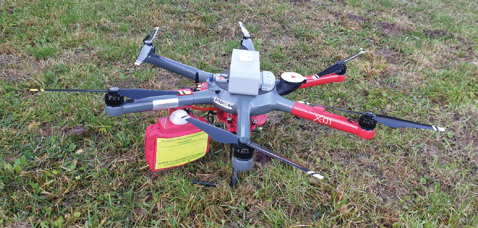
In SAR operations, time is a critical resource. Using BSLs in them saves it in many ways. Searches can be conducted faster and more efficiently. The victim can receive first aid faster in mountainous or hard-to-reach terrain. Finally - the view from above allows for better coordination of rescuers in the search area. At CUD, we have both drones equipped with thermal imaging cameras and platforms adapted to drop first aid packages.
Dedicated equipment:
Aircraft X-05, Multi-rotor Hexacopter X-01.
Service parameters:
- lead time dependent on the possibilities arising from of airspace regulations, the study area and weather conditions.
Service Description:
- making a flight with a drone equipped with a thermal imaging camera
- Observation of the search area.
- Supporting the activities of rescue units.
What you get:
Conducting search flights in the area of operations,
Pre-medical first aid.
Drones have added to the catalog of border service capabilities the ability to observe terrain from a perspective previously reserved exclusively for aircraft and helicopters. However, the drones used most often by Chinese manufacturers do not offer full cyber security for operations. The drones built at CUD stand fully domestic design, with Polish know-how, local service and a wide range of assembled sensors that remain on standby to support operations at the country's borders.

Dedicated equipment:
Aircraft X-05, Multi-rotor Hexacopter X-01,
Service parameters:
- lead time dependent on the possibilities arising from of airspace regulations, the study area and weather conditions.
Service Description:
- BSL flight equipped with a camera thermal imaging or RGB,
- real-time image analysis
What you get:
High systuation awareness during ongoing activities
We dedicate this type of service to services that, in concern for the safety of citizens must take discreet actions and detective offices.

Dedicated equipment:
Aircraft X-05, Multi-rotor Hexacopter X-01, Inspire 2.
Service parameters:
- lead time dependent on the possibilities arising from of airspace regulations, the study area and weather conditions.
Service Description:
- Performing ops with a drone equipped with a camera thermal imaging or RGB,
- Real-time observation and recording of evidence.
What you get:
Photo or video material that can be used as evidence in a case or proceeding.
With a highly skilled team in areas such as Such as unmanned systems, broad IT (including algorithms based on based on artificial intelligence and machine learning), as well as photogrammetry and remote sensing, we are able to cope with the most difficult task with which a customer reports to us. We design and construct unmanned aircraft aircraft, sensors and other specialized equipment. We create software and solve problems related to methods of photogrammetric and multispectral in precision agriculture, forest management, construction and environmental protection. In short, if you think something is impossible - contact us first. We can make the CUD work.

Dedicated equipment:
By design.
Service parameters:
- lead time and all other parameters are determined individually are determined individually.
Service Description:
- Discussing the problem with the client,
- Adoption of the final version of the solution,
- design and manufacturing,
- testing phase,
- solution implementation,
- service.
What you get:
A ready-to-implement solution.
As part of the Startup Platforms program, we implemented a project concerning development of analytical software for remote sensing and photogrammetric measurements. It is intended for entities from the agricultural and forestry sectors, as well as local government units (environmental protection). Its charv eral features are new indicators of vegetation, thermografic maps and proprietary algorithms, based on based on artificial intelligence and machine learning. The application continues to be further developed and expanded with new features to meet the needs of our customers. The application designed for agriculture and forestry forestry will be expanded to include construction and environmental aspects.

Dedicated equipment:
Customer-made raids or Aircraft X-05, Agrodron X-06, Multirotor Hexacopter X-01, Inspire 2.
Service parameters:
- subscription,
- one-time/perpetual sales
Service Description:
- Detection of mistletoe and degree of infection based on multispectral imaging,
- Modeling of tree growth and determination of grade class,
- Assessment of defoliation levels of stands,
- Accurate estimation of the number of trees and species classification,
- Creating application maps of variable fertilization, orchard thinning and spot and zone spraying,
- Automatic calculation of planting and attrition, testing of uniformity of planting,
- Hydration analysis.
What you get:
Analytical software for multispectral measurements and photogrammetric measurements based on proprietary indicators and artificial intelligence algorithms. The software is used- us for analytics of all our services.
| Name of the service | Net unit price | Minimum net price per day of work | |
|---|---|---|---|
| 01 | Conducting a photogrammetric or remote sensing | PLN 320.00/hour | PLN 2500.00 |
| 02 | Development and analysis of raw photogrammetric material or remote sensing | individually | individually |
| 03 | Development of sowing uniformity map | PLN 35.00 | PLN 3,500.00 |
| 04 | Crop condition assessment (location of problematic areas, overwintering map) | PLN 35.00 | PLN 3,500.00 |
| 05 | Development of an application map of variable fertilizer dosage (mainly nitrogen) or individualized zoned, spot or zone spraying | PLN 40.00 | PLN 4,000.00 |
| 06 | Analysis of the level of decline in plant health resulting from activity of the stress factor - deficiency or excess of water | PLN 40.00 | PLN 4,000.00 |
| 07 | Desiccation support | PLN 40.00 | PLN 4,000.00 |
| 08 | Fruit tree growth modeling, yield forecasting, map application map of differential flower thinning | PLN 40.00 | PLN 4,000.00 |
| 09 | Estimating hunting damage | PLN 35.00 | PLN 3,500.00 |
| 10 | Discharge of a biological agent in the form of a crush to control of the European corn borer | PLN 250.00/hour | individually |
| Name of the service | Net unit price | Minimum net price per day of work | |
|---|---|---|---|
| 11 | Conducting a photogrammetric or remote sensing | PLN 320.00/hour | PLN 2,500.00 |
| 12 | Development and analysis of raw photogrammetric material or remote sensing | individually | individually |
| 13 | Modeling stand growth | PLN 35.00 | PLN 3,500.00 |
| 14 | Determination of the level of defoliation of forest areas | PLN 40.00 | PLN 3,500.00 |
| 15 | Determine the degree of vegetation and health of stands | PLN 35.00 | PLN 3,500.00 |
| 16 | Monitoring the occurrence of the bark beetle | PLN 40.00 | PLN 4,000.00 |
| 17 | Monitoring for parasites - mistletoe, coniferous and deciduous | PLN 40.00 | PLN 4,000.00 |
| 18 | Inventory of forest animals | PLN 40.00 | PLN 4,000.00 |
| 19 | Search for burnt areas, detection of micro fires | PLN 40.00 | PLN 4,000.00 |
| 20 | Spatial information system updates - such as maps for design and archiving purposes | PLN 35.00 | PLN 3,500.00 |
| 21 | Inspection/assessment of damage in hard-to-reach areas | PLN 35.00 | PLN 3,500.00 |
| 22 | Discharge of a bulk biological agent in the form of a crumbler to to control star wasp | PLN 250.00/ha | individually |
| Name of the service | Net unit price | Minimum net price per day of work | |
|---|---|---|---|
| 23 | Conducting a photogrammetric or remote sensing | PLN 320.00/hour | PLN 2,500.00 |
| 24 | Making photografic or film documentation | individually | individually |
| 25 | Photogrammetric product for construction projects and design maps | PLN 35.00 | PLN 3,500.00 |
| 26 | Monitoring the progress of construction work | PLN 35.00 | PLN 3,500.00 |
| 27 | Inspections of completed investments, archiving, measurements of of surfaces and volumes | PLN 35.00 | PLN 3,500.00 |
| 28 | Inspection using a thermal imaging camera for buildings | PLN 800.00 | PLN 3,000.00 |
| 29 | Inspection of wind turbines using a camera Thermal imaging and digital RGB | PLN 800.00 | PLN 3,000.00 |
| 30 | Inspection using a thermal imaging camera for photovoltaic panels | PLN 40.00 | PLN 3,500.00 |
| 31 | Ditch capacity analysis and land reclamation assessment | PLN 35.00 | PLN 3,500.00 |
| 32 | Pulling high voltage cables | individually | individually |
| 33 | Inventory of historic buildings | PLN 40.00 | PLN 3,500.00 |
| 34 | Analysis of the status of the spatial inventory | PLN 40.00 | PLN 3,500.00 |
| Name of the service | Net unit price | Minimum net price per day of work | |
|---|---|---|---|
| 35 | Measurement of air pollution | PLN 800.00/10 pts | PLN 3,000.00 |
| 36 | Measurements of the smoke composition of industrial chimneys | PLN 800.00/10 pts | PLN 3,000.00 |
| 37 | Search for missing persons and animals | PLN 320.00/hour | PLN 2,500.00 |
| 38 | Inspection of golf courses | PLN 800.00 | PLN 5,000.00 |
| 39 | Hydrological simulations | PLN 60.00 | PLN 5,000.00 |
| 40 | Transportation of first aid supplies and coordination of rescue operations rescue efforts | PLN 320.00/hour | PLN 2,500.00 |
| 41 | Control in border traffic | PLN 320.00/hour | PLN 2,500.00 |
| 42 | Specialized monitoring from the air | individually | individually |
| 43 | Research and development activities - development and implementation of innovative solutions | individually | individually |
| 44 | Analytical software for multispectral and photogrammetric | subscription PLN 2,400.00/year | perpetual 8 000,00 zł |