Environmental measurements by drone
Benefits
Save time in getting the information you need.
Repeatability of measurements by being able to perform multiple flights.
The ability to take measurements in environments contaminated by radiological, biological, chemical or volcanic gases.
Safety for personnel operating the apparatus.
DRONIKA's innovative environmental measurement system makes it possible to quickly and accurately assess air quality with an indication of the source and type of pollution.
Capabilities
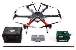
Dronika system
The DRONIKA system was developed in response to one of the major technological challenges of modern environmental protection. Precise testing of air pollution in real time has become possible thanks to our comprehensive solution. Dronika is based on the interaction of the software that visualizes the results of the tests carried out together with the tank that measures the composition of the air - Hummingbird.


Hummingbird tank
The Hummingbird tray is equipped with high-quality sensors that detect the presence of contamination, giving a real picture of the concentration of harmful substances in the sample under test, along with accurate information about the time and place of the test. It can work as a stand-alone module, but carrying out measurements falls out much more efficiently when the carrier of the hopper is a drone (unmanned device).
Drone as carrier of the Hummingbird tray
The combination of the Hummingbird tray with a drone (unmanned aerial vehicle) makes it possible to reach hard-to-reach places and simultaneously sample both spot and a large area. Data from the collected samples are simultaneously recorded on an SD card and transmitted directly from the drone to the ground station, where the program analyzes them in real time. As a result, it is possible to determine very accurately the contaminants present in water and air, and thus take preventive measures to ensure the protection of human life and health.
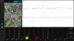
Environmental measurements
Air pollutant measurements performed include PM 2.5 (up to 1000µg/m3), PM 10 (up to 1000µg/m3), CO2, VOCs, HCHO, HCL, HCN, CL2, CO, NO2, NO, SO2, H2S, as well as humidity, pressure and air temperature.The Dronika system allows environmental analysis and report generation of measurement results. The software automatically calculates average and maximum values, while readings are available in real time. All data is geolocated, that is, described by GPS coordinates. This allows the exact location of the place where the measurement was taken.
Smog maps
Graphical presentation of the degree of air pollution in a given area, greatly facilitates and accelerates the analysis of the measurements made. It allows you to easily identify places with impaired air quality and with high accuracy indicate the sources of emission of individual harmful substances.

Want to find out more: dronika.pl
Full range of specialized services