Drones in forestry
Benefits
Increased efficiency of wood production
By more effectively identifying and locating stands infected with pests or pathogens, estimating damage, inventorying and assessing fire danger status, we increase the efficiency of timber production.
Saving time and money
Our services reduce costs - both in terms of time and labor, as well as money. Orthophotos, 3D models and NMPT give an accurate picture of forest divisions and enable geospatial inspections and updates in a much shorter time than it used to.
Helping to make optimal decisions. The data we provide helps forest entrepreneurs to take the right actions, at the right time. As a result, problems are nipped in the bud and forest management is carried out in a thoughtful and efficient manner.
Capabilities
Discharge of a biological agent in the form of a crush to control star wasp
The star wasp is a pest that every forester has surely heard of. Its gradations threaten stands of Scots pine. Fertilized females lay eggs singly on the inside of the needles. If you don't monitor and act in a timely manner, timber production losses can be very high. As with the European corn borer, its natural enemy is the buckthorn, whose larvae parasitize its eggs. An effective way to apply buckthorn is to drop it using a drone.
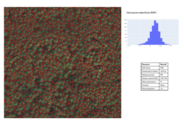
Determination of the level of defoliation of forest areas
A drone equipped with a multispectral camera makes it possible to assess the condition of a forest stand, which in this case can be manifested in the degree of defoliation, i.e. loss of leaves or needles due to external factors such as air pollution or plant diseases. Leaf loss expressed as a percentage is a criterion for assessing forest health using the bioindication method. The advantage of our service is the speed of its execution and the transparency and precision of the analysis (top view).
Inspection and damage assessment of hard-to-reach areas where physical human presence is impossible or dangerous
Some forest areas are inaccessible - this may be due to wetlands or the danger posed by falling branches. In such cases, issues of inventory and damage estimation are solved by unmanned aerial vehicles. Unlike satellite imagery, cloud cover is not a problem for low-altitude photogrammetry. In addition, the resolution of the maps is higher, making the survey more precise.
Determine the degree of vegetation and health of stands
A high-tech multispectral camera allows us to assess the condition of stands. Thus, using a wide range of indicator maps, we are able to pinpoint trees with a high probability of infection by a pest (e.g., the bark beetle) or pathogen. For forest management, this means less felling and thus more efficient production of habitat.
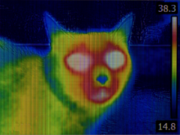
Game inventories (thermal imaging measurements)
Using unmanned aerial vehicles (rotorcraft or aircraft) equipped with thermal imaging cameras, we are able to conduct a non-invasive inventory of wild game. In view of the fight against ASF (African Swine Fever), it is extremely important to have authoritative information on the number of wild boars in a given area. Such surveys are also useful for naturalists and environmental entities.
Spatial information system updates - e.g., Forest Numerical Map.
High-resolution orthophotos are used to update the Forest Numerical Map, while point clouds can be used for spatial measurements. Moreover, thanks to CIR imaging, we are able to locate downy or weakened trees. We can obtain these products after just one raid, so we save time and money compared to other methods of operation.
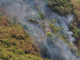
Analysis of the state of fire danger
Thermal imaging (thermographs) and multispectral (near infrared) measurements help assess fire danger. The higher the temperature of stands, the greater the likelihood of fire. In this way, it is also possible to locate micro-fires and inspect burnt areas - so as not to allow further spread or re-ignite the fire. It is a very effective and precise decision support system, thanks to its view from above, among other things.
Modeling of stand growth and boning
Accurate analysis of the various bands of light reflected from plants makes it possible to distinguish specific tree species, and also indicates their condition and degree of vegetation. Thanks to photogrammetric studies, such as the numerical land cover model and dense point cloud, it is easy to determine the growth of a stand of trees. Knowing the age, in turn, makes it possible to determine its bonification class. The results of the analysis are presented in the form of a table and a 3D model.
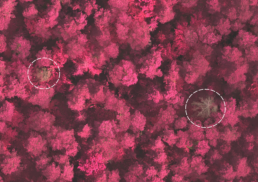
Monitoring the occurrence of parasites - mistletoe in coniferous and deciduous forests
Mistletoe is a characteristic semi-parasite that, having attached itself to the host tree, takes water and mineral salts from it. Individual mistletoes do not threaten the tree, but when they are in high numbers, they contribute to the dying of the tree. For this reason, it is very important to regularly monitor trees using a drone - so that we know the scale of the problem and where exactly and to what extent it occurs. This allows us to make optimal decisions on when to cut them down.
Full range of services for forestry