
Drones in precision agriculture
Benefits
Reducing the environmental impact
Variable rate application (VRA) and individualized spraying maps allows farmers not only to reduce production costs, but also to reduce environmental impact. Excessive application of nitrogen and other chemicals has a negative impact on biodiversity and soil quality.
Increasing crop yields
Multispectral and RGB measurements allow you to make optimal decisions and manage your farm better. By nipping risks in the bud and identifying areas with a space for improvement, you maximise your production.
Cost minimization
Variable rate application (VRA) and individualized spraying maps let farmers drastically reduce the use of pesticides, herbicides and fertilizers. In the case of pesticide costs, this is a reduction of up to 80%, and up to 30% in the case of fertilizers.
Farm monitoring
You no longer need to spent a lot of time to monitor your field - you can call us and we will conduct photogrammetry or remote sensing mission. Shortly after that you will receive our maps and analysis in .pdf or get an access to our cloud software. Questions? Do not hesitate and get in touch!
Every agricultural entrepreneur strives to maximise profits and reduce costs. With precision farming methods, he can increase the efficiency of his production, minimise the costs linked with time and money. Reducing the environmental impact by limiting the use of chemicals is also a very big advantage.
Precision farming is undoubtedly the future of agricultural economy, both in Poland and worldwide. Rapid economic development, an increasing population and ongoing climate change require us to have an innovative approach to farming and to use modern technologies.
Possibilities
Localizing and identifying problematic areas
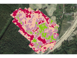
It is not an easy task to run a farm – during growing season many problems may arise, such as pests, weeds, pathogens infestation or hazardous weather conditions. It is difficult to predict the affected area and the extent of the factor that occur. And here we can come to your aid. Based on multispectral measurements, we are able to indicate these specific regions and determine the degree of current damage. This allows the farmer to nip the hazards in the bud and thus save time and money.
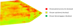
Supporting dessication
Desiccation is a chemical procedure, which aim is to dry (desiccate) the plants (mainly rapeseed) before harvesting (preparing cultivation for harvest) and fight the weeds. Thanks to the drone equipped with multispectral sensor, we are able to divide the field into the regions that should and should not be sprayed. This kind of service has a positive impact on natural environment, save a great deal of time and money and improve the quality of crops.
Determining the degree of damage caused by game or weather phenomena
The orthophoto maps that we provide precisely reflect the real condition of the farm. By comparing the situation before and after the damage, we can easily estimate the affected area. If we use multispectral sensor, we are also able to calculate the extent of damages in specific regions.

Estimating crops and counting the seedlings
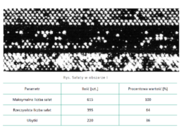
Multispectral and RGB (visible colours – red, green and blue) imagery allow us to estimate the seize of the yields and the number of seedlings. Predicting yields is very important in case of planning sales and storage. Next, counting the number of seedlings is helpful in insurance matters and assessing the condition of the plants after winter or drought.
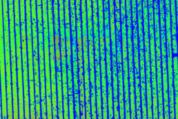
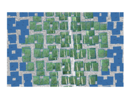
Assessing condition of plants by developing vegetation indices
After conducting the multispectral mission with a drone equipped with suitable sensor, we can develop the full range of indices maps. Every map gives us different kind of information, for example about leaves transpiration or plants’ condition after winter. Our experience let us operate with remote sensing and photogrammetry products skilfully, that is why our analysis is as precise as it is possible. NDVI is just a beginning.
Creating VRA (variable rate application) and individualized spraying maps
Efficient crop production is dependent on suitable fertilizing. Over fertilization is extremely dangerous for soil and water environment, damage the plants and make their taste worse. In view of the implementation of European Green Deal’s premises, rational fertilization not only will be a good practice, but it will become a necessity. Beside correct dose, date of application and right form of the fertilizer, precision is also very relevant in that procedure. And that is something what drones can provide.
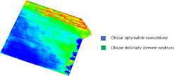
Analysis of plant’s health decline due to stress factor activity – water excess or deficiency
Owing to use of the drone equipped with thermal camera, we are able to develop thermal maps, which pixels are described with real, specific temperature. It let us evaluate transpiration level (evaporation from aerial parts of plants, such as leaves, stems and flowers) – the higher temperature, the lower transpiration. Thanks to that measurement, we can estimate the level of stress caused by excess or shortage of water.
Biological agent’s (Trichogramma) airdrop in order to combat European corn borer
European corn borer is a pest, that every farmer who grows corn heard about. If he does not conduct special monitoring or would not take appropriate steps in the case of finding it in the field, the crop loss might be even around 90%. The natural enemy of European corn borer is Trichogramma, which larva parasitise on its eggs. The effective way of Trichogramma’s application is the airdrop from a drone.
Development of a plant stand uniformity map
While preparing for the next sowing season, drone missions are invaluable help. Their goal is to map the area and work out which areas require additional work and what kind of job should be done to ensure uniform plant stand and good crops. Using photogrammetric and remote sensing methods, as well as artificial intelligence, we are able to determine the number of seedlings and losses in the beds. This allows you to optimize the production volume as well as reduce alternative costs.
Conducting photogrammetry or remote sensing mission
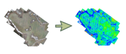
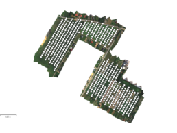
To map the interesting area, we conduct photogrammetry and remote sensing missions. Using selected drone and sensor we are able to acquire photo material, which is developed into chosen map. In the case of photogrammetry mission we use high resolution digital camera (RGB visualisation) and as far as remote sensing is concerned – multispectral cameras (it takes photos in a few different spectrum of light, inter alia near infrared).
Development and analysis of raw photogrammetry or remote sensing material
More and more agriculture entrepreneurs use drones to optimize their production and reduce the costs. Developing and analysing raw photogrammetry and remote sensing material requires specialized know-how, suitable hardware and advanced software. That is why our company provides analytic services, which let you seize the opportunities that gives you your drone.

Modelling fruit trees height, crop prediction, variable flower thinning application map
As part of precision gardening drone give us the possibility do map our crops – it allow us to estimate production potential of single fruit trees or fruit bushes. Thanks to this kind of analysis, we can control the efficiency of respective strains and results of fertilizing and other agriculture practices. We are also able to identify the orchard areas characterized by good or bad condition, and based on that develop variable rate and flower thinning application maps.